


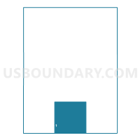
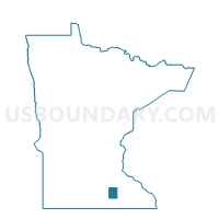
Summit Twp. Voting District, Steele County, Minnesota
About
Outline

Summary
| Unique Area Identifier | 604549 |
| Name | Summit Twp. Voting District |
| County | Steele County |
| State | Minnesota |
| Area (square miles) | 35.96 |
| Land Area (square miles) | 35.93 |
| Water Area (square miles) | 0.03 |
| % of Land Area | 99.92 |
| % of Water Area | 0.08 |
| Latitude of the Internal Point | 43.88833000 |
| Longtitude of the Internal Point | -93.22356770 |
Maps

Graphs
Select a template below for downloading or customizing gragh for Summit Twp. Voting District, Steele County, Minnesota


Neighbors
Neighoring Voting District (by Name) Neighboring Voting District on the Map
- Aurora Twp. Voting District, Steele County, MN
- Berlin Twp. Voting District, Steele County, MN
- Blooming Prairie Twp. Voting District, Steele County, MN
- Ellendale Voting District, Steele County, MN
- Geneva Twp. Voting District, Freeborn County, MN
- Lemond Twp. Voting District, Steele County, MN
- Newry Twp. Voting District, Freeborn County, MN
- Somerset Twp. Voting District, Steele County, MN
Top 10 Neighboring County Subdivision (by Population) Neighboring County Subdivision on the Map
- Somerset township, Steele County, MN (732)
- Ellendale city, Steele County, MN (691)
- Aurora township, Steele County, MN (574)
- Berlin township, Steele County, MN (519)
- Lemond township, Steele County, MN (501)
- Summit township, Steele County, MN (466)
- Newry township, Freeborn County, MN (450)
- Blooming Prairie township, Steele County, MN (430)
- Geneva township, Freeborn County, MN (421)
Top 10 Neighboring Place (by Population) Neighboring Place on the Map
Top 10 Neighboring Unified School District (by Population) Neighboring Unified School District on the Map
- Owatonna Public School District, MN (29,301)
- NRHEG School District, MN (5,276)
- Blooming Prairie Public School District, MN (4,223)
Top 10 Neighboring State Legislative District Lower Chamber (by Population) Neighboring State Legislative District Lower Chamber on the Map
- State House District 26A, MN (39,465)
- State House District 26B, MN (38,912)
- State House District 27A, MN (35,241)
Top 10 Neighboring State Legislative District Upper Chamber (by Population) Neighboring State Legislative District Upper Chamber on the Map
Top 10 Neighboring 111th Congressional District (by Population) Neighboring 111th Congressional District on the Map
Top 10 Neighboring Census Tract (by Population) Neighboring Census Tract on the Map
- Census Tract 9608, Steele County, MN (3,744)
- Census Tract 1801, Freeborn County, MN (2,879)
- Census Tract 9605, Steele County, MN (2,830)
- Census Tract 1802, Freeborn County, MN (2,735)